Intelligence That Adapts and Restores
KibiraAI delivers climate services for Africa's forests and cities, transforming raw data into actionable guidance that reduces emissions and protects lives.
Forest Intelligence
Predict risk, plant smarter, verify carbon
AI maps vulnerable zones, generates native-species plans, and tracks sequestration for carbon credits.
Urban Services
Cool, protect, feed & hydrate cities
Heat mapping, flood early-warnings, food-garden advisory, and smart water monitoring — delivered digitally.
Pillar 1 — Forest Intelligence
AI That Predicts, Plants & Verifies
KibiraAI uses satellite imagery, land-use data, and ecological models to pinpoint where forests are most at risk — then generates region-specific reforestation plans using native species matched to local soil and rainfall.
Every intervention is tracked with science-backed biomass monitoring, producing verifiable carbon-credit reports that create direct revenue for communities.
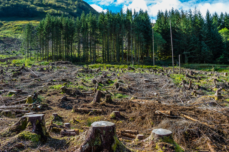
Deforestation Risk Mapping
AI-powered analysis of satellite imagery and land-use patterns identifies at-risk areas before trees are lost, allowing for targeted intervention.
Native Species Optimization
We generate planting strategies using indigenous species suited to local soil and rainfall, increasing survival rates by up to 40% compared to monocultures.
Carbon Verification Ecosystem
Science-backed tracking of biomass growth translates into verifiable carbon credits, creating direct revenue streams for forest-dependent communities.
AI Forest Acoustic Sentinel
Beyond data — real-time forest protection. Low-cost IoT sound sensors deployed across Uganda's at-risk forests (Mabira, Bugoma, Bwindi buffer zones) use a trained neural network to detect illegal logging activity and alert rangers within seconds.
🔊 Launch Forest Sentinel →Acoustic Detection
Solar-powered IoT microphones deployed across at-risk forests use a trained neural network to classify chainsaw and axe sounds in real-time, distinguishing logging from natural forest sounds like thunder or animal calls.
95% detection accuracyGPS Triangulation & Alerts
Multiple sensor nodes triangulate the exact GPS location of detected logging activity. Instant SMS and WhatsApp alerts are pushed to community forest rangers and Uganda's National Forestry Authority within seconds.
< 30 second alert timeEvidence & Dashboard Logging
Every detection event is logged on the KibiraAI dashboard with timestamp, GPS coordinates, confidence score, and audio classification. Optional drone dispatch captures photographic evidence for prosecution.
100% event traceabilityPredictive Feedback Loop
Detection data flows back into KibiraAI's deforestation risk model, making future predictions sharper. Patrol routes are optimized based on hotspot patterns, reducing ranger workload by up to 60%.
Self-improving AI modelDetection Pipeline
Sound Captured
IoT mic detects chainsaw/axe audio
AI Classifies
TensorFlow Lite model on-device
Alert Dispatched
SMS/WhatsApp to rangers in < 30s
Evidence Logged
GPS, timestamp, audio on dashboard
Africa-wide scalability: Replicable across the Congo Basin (1.5M ha lost/year), Kenya's community forests, and Ghana's cocoa-belt forests. Tech stack: TensorFlow Lite on Raspberry Pi Zero + solar panel + LoRaWAN for low-power, long-range connectivity in remote areas.

Pillar 2 — Urban Resilience
Digital Services That Cool, Protect & Feed Cities
KibiraAI delivers lightweight, data-driven services that help urban communities manage heat, avoid floods, grow food, and secure water — all without heavy capital infrastructure.
Through early-warning analytics, localized advisories, and AI-powered planning, city leaders and residents get the intelligence they need to act before crises hit.
Heat Stress Mitigation
Our AI maps 'Urban Heat Islands' and provides digital roadmaps for cooling corridors, recommending native species placement to reduce neighborhood heat by up to 5°C.
Early Warning Flood Analytics
By processing topography and soil moisture data, we provide early warnings to dense informal settlements, giving families time to respond before flooding occurs.
Urban Garden Advisory
Innovation for food insecurity: Digital technical support for vertical and rooftop farming, optimizing yield in limited urban spaces.
Smart Water Monitoring
Addressing water scarcity through digital leakage detection and smart distribution patterns, ensuring reliable access to clean water in growing cities.
Urban Heat & Flood Early Warning System
Beyond data — predictive urban protection. A hyperlocal AI system for Kampala and African cities that combines satellite thermal imagery, weather data, and drainage topology to predict heat extremes and flash floods before they strike.
🚀 Launch Live System →Hyperlocal Heat Island Mapping
Satellite thermal imagery (Landsat Band 10) combined with ground-level data maps neighborhood-level heat intensity across African cities, identifying which informal settlements like Bwaise, Katanga, and Namuwongo are dangerously hot.
50m resolution heat maps72-Hour Flood Prediction Engine
An ML model processes real-time weather forecasts, soil saturation levels, and urban drainage topology to predict flash floods 24–72 hours ahead, pushing SMS and WhatsApp alerts to residents in flood-prone zones.
24–72h advance warningParish-Level Climate Action Plans
AI generates specific intervention plans per neighborhood — e.g., 'Plant 200 Terminalia mantaly trees along Jinja Road to reduce heat by 3°C and intercept 40% of stormwater runoff' — ready for KCCA and NGO implementation.
Actionable per-ward plansClimate Justice Evidence
Maps and data proving which communities bear the worst climate impact help NGOs and city authorities direct adaptation funding equitably — supporting advocacy, policy change, and international climate finance applications.
Data-backed equity reportsEarly Warning Pipeline
Satellite Scan
Landsat thermal + Sentinel-1 radar
AI Analysis
ML predicts heat/flood risk per ward
Alert Pushed
SMS/WhatsApp to at-risk residents
Action Plan
Per-parish interventions generated
Target cities: Kampala (primary), Lagos, Nairobi (Mathare/Kibera), Dar es Salaam, Accra (Odaw River basin). Uses freely available Sentinel-1 radar for flood detection and Landsat thermal bands for heat mapping — no hardware deployment needed.
The Complete Pipeline
Data → Detection → Action
Three integrated layers that transform climate intelligence into measurable impact across Africa's forests and cities.
Layer 1
Educate & Advise
Dr. Kibira AI
Users query the AI for region-specific data on deforestation, native species, carbon potential, and climate-smart farming practices.
Layer 2
Detect & Protect
Forest Acoustic Sentinel
IoT sound sensors detect illegal logging in real-time, alert rangers, and feed data back into the deforestation risk model.
Layer 3
Predict & Prepare
Urban Heat & Flood AI
Satellite and weather data predict heat extremes and flash floods, push early warnings, and generate neighborhood-level climate action plans.
The Digital Service Stack
KibiraAI acts as a climate operating system, turning data into guidance for local governments, NGOs, and community leaders. This keeps intervention fast, affordable, and scalable.
Data-to-Action
From satellite signals to actionable playbooks, every insight is designed for immediate use in the field.
Community First
Designed for low-bandwidth environments with clear, local-language friendly recommendations.
Verified Impact
Continuous monitoring produces evidence for climate finance, carbon credits, and public accountability.
Workflow
How KibiraAI Works
1. Data Capture
Satellite, climate, and local inputs establish real-time context.
2. AI Diagnosis
Models detect risk zones and forecast climate stress events.
3. Action Playbooks
Communities receive tailored actions for forests and cities.
4. Verified Outcomes
Progress is monitored and validated for climate finance.
3.9M
Hectares protected yearly
Risk mapped to prevent loss
95%
Logging detection rate
Acoustic AI forest sentinel
5°C
Urban cooling potential
Heat corridors + tree placement
72h
Flood early warning
Preparedness for dense neighborhoods
40%
Higher survival
Native species optimization
< 30s
Alert response time
Real-time ranger notification